

Файл:PIA19420-Mercury-NorthHem-Topography-MLA-Messenger-20150416.jpg


Исходный файл (3750 × 3752 пкс, размер файла: 3,49 МБ, MIME-тип: image/jpeg)

Краткое описание
| Описание |
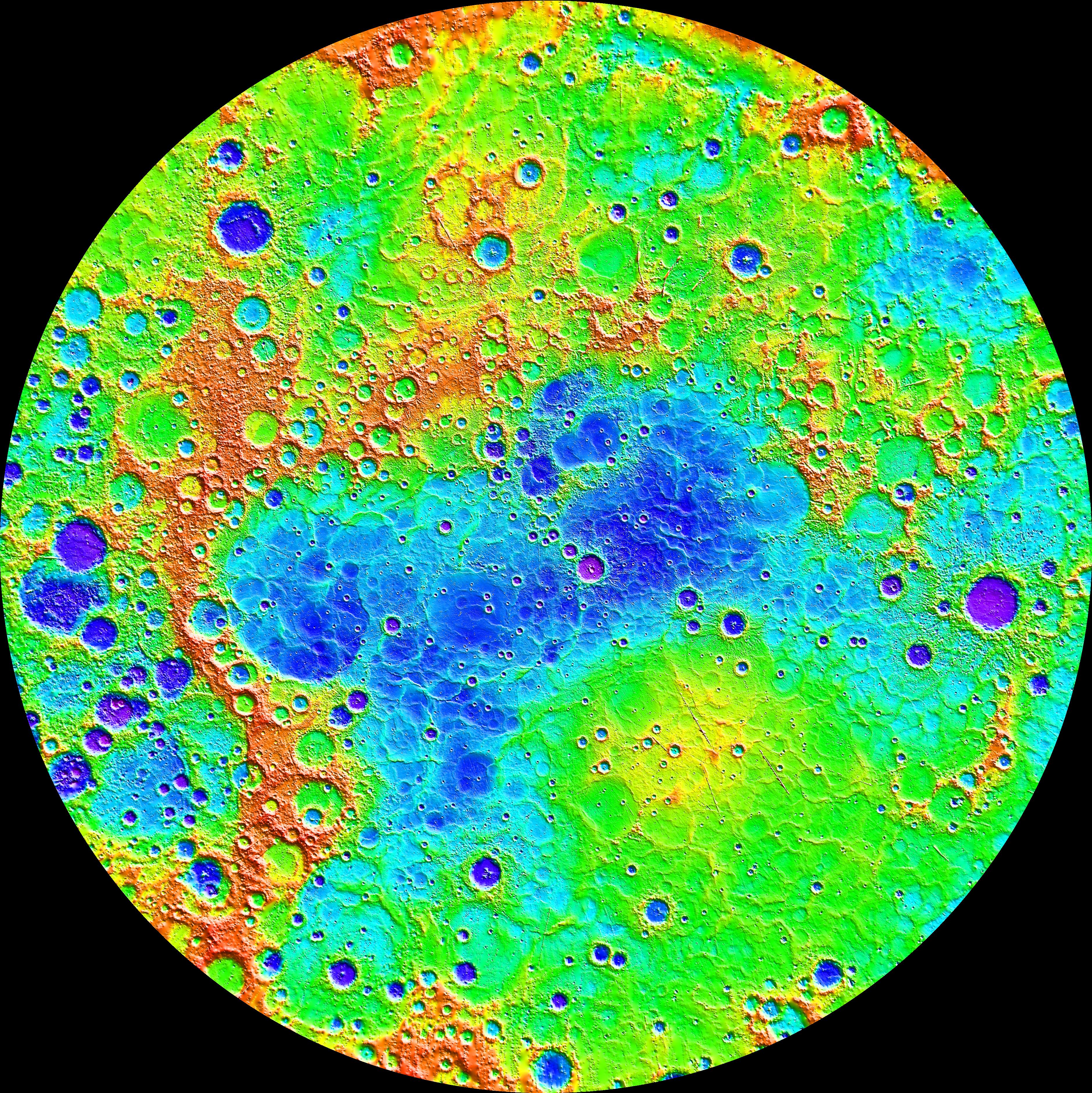
English: PIA19420: The Ups and Downs of Mercury's Topography
http://photojournal.jpl.nasa.gov/catalog/PIA19420 Measurements from MESSENGER's MLA instrument during the spacecraft's greater than four-year orbital mission have mapped the topography of Mercury's northern hemisphere in great detail. The view shown here is an interpolated shaded relief map of these data. The lowest regions are shown in purple, and the highest regions are shown in red. The difference in elevation between the lowest and highest regions shown here is roughly 10 kilometers! Among the prominent features visible here are the smooth northern volcanic plains and the enigmatic northern rise. The low-lying craters near the north pole host radar-bright materials, thought to be water ice. Linear artifacts can be seen in some areas of this map. These are due to individual MLA tracks that need minor adjustments in order to fit the rest of the data. Crossover analysis and better knowledge of the spacecraft position can be used to adjust these tracks and improve the map. Instrument: Mercury Laser Altimeter (MLA) Center Latitude: 90° Center Longitude: 0° E Latitude Range: 45° to 90° N The MESSENGER spacecraft is the first ever to orbit the planet Mercury, and the spacecraft's seven scientific instruments and radio science investigation are unraveling the history and evolution of the Solar System's innermost planet. In the mission's more than four years of orbital operations, MESSENGER has acquired over 250,000 images and extensive other data sets. MESSENGER's highly successful orbital mission is about to come to an end, as the spacecraft runs out of propellant and the force of solar gravity causes it to impact the surface of Mercury in April 2015. |
| Дата | |
| Источник | http://photojournal.jpl.nasa.gov/jpeg/PIA19420.jpg |
| Автор | NASA/Johns Hopkins University Applied Physics Laboratory/Carnegie Institution of Washington |
Лицензирование

|
Этот файл находится в общественном достоянии (англ. public domain), так как он был создан NASA (Национальным управлением по аэронавтике и исследованию космического пространства). Политика авторского права NASA гласит, что «Материал NASA не защищается авторским правом, если не указано иное». (См. Template:PD-USGov, страницу политики авторского права NASA или политику использования изображений JPL.) |  |
 |
Предупреждения:
|
| Аннотации | Это изображение аннотировано: Просмотреть аннотации на Викискладе |
История файла
Нажмите на дату/время, чтобы увидеть версию файла от того времени.
| Дата/время | Миниатюра | Размеры | Участник | Примечание | |
|---|---|---|---|---|---|
| текущий | 15:56, 20 апреля 2015 | | 3750 × 3752 (3,49 МБ) | wikimediacommons>Drbogdan | User created page with UploadWizard |
Использование файла
Следующая страница использует этот файл:
